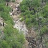
The advent of remote sensing technology such as LIDAR (Light Detection and Ranging) has profound implications for the restoration of our watersheds. KRE is developing the Erosion Analysis Restoration Technique™ Toolset which uses LIDAR and ArcView GIS to model landscapes and identify areas of damaging erosion. Most importantly the toolset prioritizes treatment areas based on restoration potential, cost, and techniques.
The use of the EARTh™ allows for the “scaling-up” of analysis to an entire watershed, ranch, Forest Service or BLM District, Tribal Reservation, or larger area.
The Erosion Analysis Restoration Technique™ GIS toolset:
1) Finds the most damaging areas of erosion on the landscape (called headcutting) and prioritizes treatments by cost and restoration effectiveness.
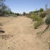
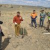
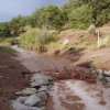
2) Finds the most effective areas for restoration on the landscape by the plug and pond technique, which restores gullies to their historic channel, raises water tables, captures sediment, creates wetlands and reduces downstream flooding.
Running this analysis on a landscape allows efforts to focus on locations with either severe erosion, high restoration potential, or both. Restoration of smaller channels or wetlands can be performed by hand or with small machinery, be at little risk of failure, and lead to landscape-wide improvements in watershed function and drought protection. Relatively healthy channels or channels eroded beyond repair can be left alone. The EARTh™ toolset can also design and prioritize treatments that mitigate flooding and capture sediment after wildfire to re-build wetlands and restore our watersheds, which changes a damaging flood into a benefit for the landscape.